



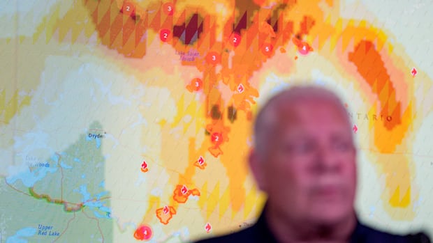
Currently, there are 145 wildfires active in northwestern Ontario, as per the latest information from Ontario Forest Fires, which is one less than what was reported on Tuesday night.
Among these fires, 41 are categorized as not under control, five are being contained, nine are controlled, and the remainder are under observation.
Evacuation orders or alerts continue to be in place for regions near the following fires:
The most significant wildfire in this area, referred to as Thunder Bay 36, remains uncontrolled and covers over 318,000 hectares.
The Ministry of Natural Resources has implemented an Implementation Order for areas around Dryden 36 to ensure public safety and facilitate fire suppression efforts.
This Implementation Order allows the ministry to issue formal and legally binding restrictions on activities and manage access within emergency zones.
“Fire Ranger crews, helicopters and heavy equipment operators are assigned to suppression efforts,” stated Ontario’s Aviation, Forest Fires and Emergency Services (AFFES) during Tuesday evening’s update.
“Recent rainfall over the last few days has contributed to a decrease in fire activity, enabling crews to make substantial progress along the fire line.”
Aerial (drone) images of Thunder Bay, Ont., shrouded in smoke from forest fires on July 15, 2026. (Marc Doucette/CBC)
Forest fire danger ratings mainly fall into low or moderate categories throughout the northwest; however, there are some areas with high risk in Fort Frances, Kenora, Red Lake and Sioux Lookout fire management regions.
“Despite recent heavy rainfall across the northwest region over several days, the fire hazard is beginning to rise again,” noted Ontario Forest Fires in a Facebook post on Wednesday.
“The potential for holdover lightning fires continues to be a concern. The public is urged to exercise extreme caution and avoid active fires while Fire Rangers and aerial suppression teams carry out their work.”
Ontario Forest Fires mentioned that infrared scanning aircraft have been operating overnight into early morning hours to detect hotspots within active fires.
An earlier Facebook post by the ministry indicated that “identifying hotspots aids crews in starting mop-up operations and verifies when a fire can be safely declared extinguished.”
New Wildfires Reported in Northwestern Ontario
Twelve new wildfires were confirmed by Tuesday evening:
Fort Frances 45 (FOR045) is located on an island at Bartley Lake. The fire covers 0.1 hectares and is currently being observed. Dryden 44 (DRY044) is situated roughly 17 kilometers west of Highway 599 and southeast of Press Lake. This non-controlled fire spans 0.1 hectares. Dryden 45 (DRY045) is found at the northeast end of Rice Lake. This also non-controlled fire measures 0.1 hectares. Thunder Bay 61 (THU061) is located about 1.5 kilometers east of Wawang Lake and northwest of Little Harry Lake. This non-controlled blaze covers an area of 0.1 hectares. Nipigon 76 (NIP076) is positioned near Jobes Lake approximately 27 kilometers southeast of Fort Hope. The uncontrolled fire stretches across150 hectares. Nipigon 77 (NIP077) and Nipigon78 (NIP078) are both situated far north about16 kilometers north of Webequie; Nipigon77 measures70 hectares while Nipigon78 covers35 hectares-both remain uncontrolled. Nipigon79 (NIP079) is located far north approximately81 kilometers northeast of Webequie; this non-controlledfire encompasses5hectares. Nipigon80(NIP080)&Nipigon81(NIP081)-locatedaround111kilometerseastof Webequie-measure10&80hectaresrespectively&remainuncontrolled. Nipigon82(NIP082)-situatedapproximately12kilometersnorthwestof Missisa Lake-covers8hectares&isnotundercontrol. Sioux Lookout103(SLK103)isfoundonanislandat Wapesi Lakewithanareaof0.1hectaresandisnotundercontrol.
Highway Closures Currently Active
The province’s interactive highway map indicates that Highway527closure at Kiashke Zaaging Anishinaabek -Gull Bay First Nation -has been extended up until its junction with Highway811.
Highway811 remains closed due to ongoing wildfire activity except for local traffic evacuating from affected areas.
The First Nation is still under a mandatory evacuation order after lightning increased surrounding wildfires around their community up to six total accordingtoareleaseissuedbythecommunityearly Tuesdaymorning. p >
In an update released Monday evening, the Ontario Provincial Police(OPP )North West Region said: p >
“The OPP is assisting MNR with an evacuation order regarding Gull Bay First Nation which was previously under self-evacuation guidelines. People livinginareas requiringmandatoryevacuationshavebeenaskedtoleaveimmediatelyandseekrefugeawayfromactivefires.” p >
The police emphasized that other communities will be monitored closely, and residents should stay informed & be readytoactquicklyifthey receiveadditionalevacuationordersoradvisories.
“More information will follow as it becomes available,” added OPP. p >
OPP strongly encourages individualsfor theirsafetyandsafetyofemergencyresponders: p >
- Stay clearfromaffectedregionsandrefrainfromvisitingwildfiresitesfortakingphotosorvideos.
- Remain calm whilst adheringtoall evacuation mandates& instructions issuedbylocalauthorities.
- Avoidnon-essentialtravelinimpactedareas.
- Keepmonitoringofficialchannelsforlatestupdatesregardinginformationandevacuationnews.
If you must evacuate, take essential medications, papers for identification &importantdocuments, mobile devices/chargers, and necessary items neededforfamilymembersincludingpets.
Two New Fires Observed In Northeastern Ontario
This Wednesday saw two new wildfires reported from northeastern Ontario: P>Cochrane47(COC047)is361hectareslocatedabout10kilometresnorthof Missisa Lake. Thisfireismonitored. Haliburton23(HAL023)is0.1hectarealongtheeastsideofthe Highway17approximate distanceof0.6 kilometerwestof Holden Lakeand0.5 kilometer east from Smith Lake. Thefirehasnotbeencontained P >
As noted Wednesdayevening41activewildfirescurrentlyexistintheeasternregion. Fourarenotcontrolledwhileoneisincontainmentthreehavebeensuccessfullymanagedwithremainingonesbeingobserved
Fire danger ratings remain lowtomoderatethroughoutthisnortheasternarea yetapocketinhighriskexistswithin Greater Sudburyregion
Total Evacuees Reaches2861 h2 >
The number has now surpassed2800wildfire evacuees coming from more than adozencommunitiesacross Ontarioaccordingtoa reportreleasedlateafternoonby Jill Dunlop, the Minister Of Emergency Preparedness And Response
They’re currently stayingat eightofficialhostcommunities
Additionally, four Ontario Corps partnersalongwith17Ontario Corps volunteers have been deployedfor assistance. Furthermore, theprovincehasprovidedequipment/suppliesconsistingof: P >
- 312airpurifiers
- 84airfilters
- Five air scrubbers
- 2640 N-95 masks
- 4340 hygiene kits
- 80food hampers
An effort involving Feed Ontario&OFTIndigenous Friendship Centresisshipping/distributingfoodassistanceforevacuees. Global Medicalsodeliveredvitalresourcesattheevacuationreceptioncentreat Fort William Gardens Arena
‘Enhanced Monitoring’ Status For Thunder Bay Transitioning
The Cityofthe Thunder Bayistransitioningfromactiveemergencycoordinationtoenhancedmonitoringaswildfireconditionsinnorthwestern Ontariocontinuetobeseriousbutstable.. andanewroundofevacuationsarenotanticipatedatthemoment. thecityannouncedinupdatelate Wednesdayafternoon.
 That said, the cityremindsitsresidents thatwildfireremainactive throughouttheregion, severalcommunitiesstillunder evacuationordersoralerts.
“The city stands readyt o providehelpiffurtherassistancebecomesnecessary.”
Residentsareencouragedtotakeprecautionarymeasuresreducingwildfireriskaroundhomes/propertiesbyimplementing Fire Smartprincipleswhichinclude:
Keepinggrasscutshortandwellmaintained. Removingcombustiblematerialsaroundbuildings/structures. Keepingclearaccess homes/drives. Properdisposalofywardebris,<brush etc
Source link
The Cityofthe Thunder Bayistransitioningfromactiveemergencycoordinationtoenhancedmonitoringaswildfireconditionsinnorthwestern Ontariocontinuetobeseriousbutstable.. andanewroundofevacuationsarenotanticipatedatthemoment. thecityannouncedinupdatelate Wednesdayafternoon.
“The city stands readyt o providehelpiffurtherassistancebecomesnecessary.”
Residentsareencouragedtotakeprecautionarymeasuresreducingwildfireriskaroundhomes/propertiesbyimplementing Fire Smartprincipleswhichinclude:
Keepinggrasscutshortandwellmaintained. Removingcombustiblematerialsaroundbuildings/structures. Keepingclearaccess homes/drives. Properdisposalofywardebris,<brush etc
Source link