


A series of severe thunderstorms prompted Environment Canada to issue tornado warnings for the London and Brantford, Ont., areas on Tuesday evening.
Those warnings, along with severe thunderstorm alerts, have since been lifted across southwestern Ontario, leaving it uncertain if a tornado actually touched down.
Thunderstorm warnings remained active as of 8:20 p. m. for regions east of Hamilton and in the Niagara Region, cautioning about damaging winds and hail up to the size of quarters.
“Emergency Management Ontario recommends that you take cover immediately if threatening weather approaches,” the agency said.
![]() A fallen tree on Burnside Drive in east London, Ont. was blocking the driveway of a fourplex. (Jack Sutton/CBC)
The London Fire Department received numerous reports about downed trees and power lines, primarily in London’s east end. According to London Hydro, over 2,000 customers in the Argyle neighbourhood lost power as of 7 p. m., with restoration expected by 6 a. m.
The City of London reported at least 50 instances of downed trees following the storm.
“City crews continue to assess and address tree damage along roads and in public spaces, responding to urgent issues on a priority basis. Initial priorities include clearing blocked roads and addressing trees impacting homes, structures or vehicles,” the statement read, adding it could take weeks to respond to all cleanup requests.
WATCH | Funnel cloud spotted in London, Ont.:
A fallen tree on Burnside Drive in east London, Ont. was blocking the driveway of a fourplex. (Jack Sutton/CBC)
The London Fire Department received numerous reports about downed trees and power lines, primarily in London’s east end. According to London Hydro, over 2,000 customers in the Argyle neighbourhood lost power as of 7 p. m., with restoration expected by 6 a. m.
The City of London reported at least 50 instances of downed trees following the storm.
“City crews continue to assess and address tree damage along roads and in public spaces, responding to urgent issues on a priority basis. Initial priorities include clearing blocked roads and addressing trees impacting homes, structures or vehicles,” the statement read, adding it could take weeks to respond to all cleanup requests.
WATCH | Funnel cloud spotted in London, Ont.: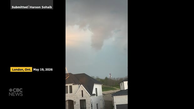 Possible funnel cloud seen in London as tornado warnings issued across region
Severe thunderstorms rolling through southwestern Ontario on Tuesday led to tornado warnings for London, St. Thomas, Woodstock and other areas. In London’s Westmount area, Haroon Sohaib captured what looked like a rotating funnel cloud from his window. As of Tuesday evening, it’s still unclear whether a tornado touched down in or near the city.
On Burnside Drive, neighbors were out checking for damage to their homes and vehicles. Many properties had fallen trees scattered across their yards. The residents of a fourplex had been watching the storm from indoors and mentioned it was tough to see what was happening outside.
“The rain started, and I ran up to see; it was like white-you couldn’t see the fence,” said Sue Rimell, one of the residents. “Then our fences started going in and out before we noticed trees falling.”
Afterward they discovered a large uprooted tree blocking their driveway.
Possible funnel cloud seen in London as tornado warnings issued across region
Severe thunderstorms rolling through southwestern Ontario on Tuesday led to tornado warnings for London, St. Thomas, Woodstock and other areas. In London’s Westmount area, Haroon Sohaib captured what looked like a rotating funnel cloud from his window. As of Tuesday evening, it’s still unclear whether a tornado touched down in or near the city.
On Burnside Drive, neighbors were out checking for damage to their homes and vehicles. Many properties had fallen trees scattered across their yards. The residents of a fourplex had been watching the storm from indoors and mentioned it was tough to see what was happening outside.
“The rain started, and I ran up to see; it was like white-you couldn’t see the fence,” said Sue Rimell, one of the residents. “Then our fences started going in and out before we noticed trees falling.”
Afterward they discovered a large uprooted tree blocking their driveway.
![]() On Burnside Drive in east London, a fallen tree pulled down power lines onto Kevin and Carole Landry’s car. (Jack Sutton/CBC)
Young mentioned that earlier that afternoon another significant storm had already passed through London bringing winds close to 90 km/h while another dangerous line of storms was moving eastward.
This strong wind surprised Kevin and Carole Landry when they looked out their window just as they saw a tree coming towards them.
“The [Environment Canada] warning came up almost instantaneously as soon as I saw the tree,” Carole said. “So we ran down into the basement just before everything hit.”
The flying tree ended up landing on their front lawn while another fell onto one of their cars taking down some power lines too.>
Environment Canada later issued tornado warnings for communities east of London including Woodstock and Brantford-Brant County; those have since been lifted.>
On Burnside Drive in east London, a fallen tree pulled down power lines onto Kevin and Carole Landry’s car. (Jack Sutton/CBC)
Young mentioned that earlier that afternoon another significant storm had already passed through London bringing winds close to 90 km/h while another dangerous line of storms was moving eastward.
This strong wind surprised Kevin and Carole Landry when they looked out their window just as they saw a tree coming towards them.
“The [Environment Canada] warning came up almost instantaneously as soon as I saw the tree,” Carole said. “So we ran down into the basement just before everything hit.”
The flying tree ended up landing on their front lawn while another fell onto one of their cars taking down some power lines too.>
Environment Canada later issued tornado warnings for communities east of London including Woodstock and Brantford-Brant County; those have since been lifted.>
![]() Houses along Burnside Drive in east London had trees uprooted and power lines downed by Tuesday’s storm. (Jack Sutton/CBC)>If you have photos or videos from this storm or know about damage occurring in your neighborhood please email londonnewstips@cbc. ca.
Houses along Burnside Drive in east London had trees uprooted and power lines downed by Tuesday’s storm. (Jack Sutton/CBC)>If you have photos or videos from this storm or know about damage occurring in your neighborhood please email londonnewstips@cbc. ca.
Source link
Possible funnel cloud seen in London as tornado warnings issued across region
Severe thunderstorms rolling through southwestern Ontario on Tuesday led to tornado warnings for London, St. Thomas, Woodstock and other areas. In London’s Westmount area, Haroon Sohaib captured what looked like a rotating funnel cloud from his window. As of Tuesday evening, it’s still unclear whether a tornado touched down in or near the city.
On Burnside Drive, neighbors were out checking for damage to their homes and vehicles. Many properties had fallen trees scattered across their yards. The residents of a fourplex had been watching the storm from indoors and mentioned it was tough to see what was happening outside.
“The rain started, and I ran up to see; it was like white-you couldn’t see the fence,” said Sue Rimell, one of the residents. “Then our fences started going in and out before we noticed trees falling.”
Afterward they discovered a large uprooted tree blocking their driveway.
Winds Exceeding 90 Kilometers an Hour
Earlier that day, Environment Canada discussed potential tornado activity in the London area. “The wind is the main threat with this,” Alyssa Young, a meteorologist with Environment Canada told CBC’s Afternoon Drive shortly before 6 p. m. “There’s a threat of winds exceeding 90 kilometers an hour as well as possible spinning rotational winds.” Environment Canada indicated that this storm system could produce wind gusts up to 110 km/h along with quarter-sized hail and heavy rainfall.Peculiarly Warm Temperatures
Younger explained that conditions for severe weather formed after unusually warm temperatures over two days collided with an advancing cold front.> “That cold front has provided a bit of a trigger,” she said. “The collision between these storms at that boundary increases potential for tornadoes.” > The extent of damage throughout the region is still being evaluated; CBC News will provide updates should any Tornado be confirmed.Source link


