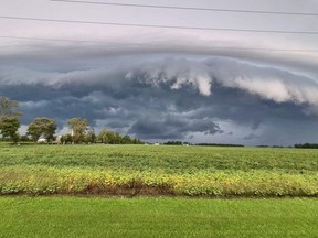





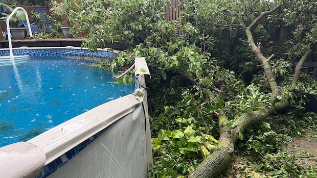
Windsor is dealing with hundreds of storm-related service requests after two days of intense weather, as city crews work to clear fallen trees and other damage – while meteorologists caution that the chance for more severe thunderstorms continues into the fall.
The City of Windsor reported on Friday that over 400 requests had come in over the past two days regarding downed trees and storm damage affecting public property.
Forestry teams, along with hired contractors, are focusing on emergency situations, dangerous trees, downed trees, power-line issues, and the areas hit hardest by the storms, according to a news release from the city.
Buckingham Drive is still closed between Wyandotte Street E. and Riverside Drive E. as crews work on tree damage caused by the storm. Detour signs have been set up.
WATCH | What 1 Windsor neighbourhood looked like after Thursday’s storm: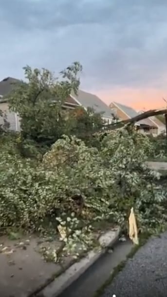 This is what 1 Windsor neighbourhood looked like after Thursday’s storm tore through
Windsor and Essex County experienced significant impact from storms Thursday evening, as Environment Canada indicated their radar detected a tornado in the vicinity. The CBC’s Chris Ensing went out to see firsthand what occurred and spoke with residents who witnessed it all.
The city is also collaborating with ENWIN Utilities to manage trees that are interfering with electrical infrastructure, noting that some large, mature trees were damaged and need heavy equipment for removal.
Residents should report downed wires to ENWIN at 519-255-2727 and use either the Windsor 311 app or online portal to report any storm-related tree damage on municipal property.
City officials ask residents not to submit duplicate requests since multiple reports can hinder response times.
The collection of tree waste related to the storm is set to begin next week, coinciding with regular yard-waste collection days for residents.
Residents are reminded that branches should be no longer than four feet long, no thicker than four inches, and weigh no more than 44 pounds. Where possible, please tie branches together.
Other types of storm-related tree waste not meeting these guidelines can be dropped off free of charge at the City’s Public Drop Off Depot located at 3560 North Service Road E.
This cleanup follows a series of severe thunderstorms that swept through Essex County Thursday night, causing strong winds, power outages, and extensive tree damage.
We still have several weeks of midsummer-like weather possible.- Rob Kuhn, severe weather meteorologist
Rob Kuhn, a severe weather meteorologist from Environment and Climate Change Canada’s Ontario Storm Prediction Centre, stated radar images suggest that the storm which moved across the Detroit River into Windsor’s Riverside area likely caused a tornado.
The Northern Tornadoes Project has yet to officially confirm whether there was a tornado or determine its strength or path.
“Radar imagery I saw from Detroit Doppler radar suggested a good likelihood that it could have been from a tornado,” Kuhn told .
Investigations by the Northern Tornadoes Project usually take one to two days according to Kuhn; currently crews are examining multiple potential tornado reports throughout southwestern Ontario stemming from Wednesday and Thursday storms.</PKuhn mentioned these investigations may include ground surveys as well as drone assessments when feasible for evaluating damage.”
This is what 1 Windsor neighbourhood looked like after Thursday’s storm tore through
Windsor and Essex County experienced significant impact from storms Thursday evening, as Environment Canada indicated their radar detected a tornado in the vicinity. The CBC’s Chris Ensing went out to see firsthand what occurred and spoke with residents who witnessed it all.
The city is also collaborating with ENWIN Utilities to manage trees that are interfering with electrical infrastructure, noting that some large, mature trees were damaged and need heavy equipment for removal.
Residents should report downed wires to ENWIN at 519-255-2727 and use either the Windsor 311 app or online portal to report any storm-related tree damage on municipal property.
City officials ask residents not to submit duplicate requests since multiple reports can hinder response times.
The collection of tree waste related to the storm is set to begin next week, coinciding with regular yard-waste collection days for residents.
Residents are reminded that branches should be no longer than four feet long, no thicker than four inches, and weigh no more than 44 pounds. Where possible, please tie branches together.
Other types of storm-related tree waste not meeting these guidelines can be dropped off free of charge at the City’s Public Drop Off Depot located at 3560 North Service Road E.
This cleanup follows a series of severe thunderstorms that swept through Essex County Thursday night, causing strong winds, power outages, and extensive tree damage.
We still have several weeks of midsummer-like weather possible.- Rob Kuhn, severe weather meteorologist
Rob Kuhn, a severe weather meteorologist from Environment and Climate Change Canada’s Ontario Storm Prediction Centre, stated radar images suggest that the storm which moved across the Detroit River into Windsor’s Riverside area likely caused a tornado.
The Northern Tornadoes Project has yet to officially confirm whether there was a tornado or determine its strength or path.
“Radar imagery I saw from Detroit Doppler radar suggested a good likelihood that it could have been from a tornado,” Kuhn told .
Investigations by the Northern Tornadoes Project usually take one to two days according to Kuhn; currently crews are examining multiple potential tornado reports throughout southwestern Ontario stemming from Wednesday and Thursday storms.</PKuhn mentioned these investigations may include ground surveys as well as drone assessments when feasible for evaluating damage.” Kuhn explained that this type of weather pattern isn’t uncommon for southwestern Ontario during summer months.
The area often experiences hot humid air moving northward from Gulf Coast regions. On Thursday afternoon Windsor-Essex was positioned near the northern edge of an ongoing heat wave where an advancing cold front helped ignite severe thunderstorms.
The thunderstorms came into Essex County from Michigan leading up damaging winds along with power outages alongside what appeared likely as a tornado in Riverside. Kuhn pointed out they had identified potential threats for extreme thunderstorms well ahead before Thursday’s event- issuing warnings hours prior when conditions became favorable. While what happened on Thursday doesn’t guarantee further severe storms will follow suit later on he affirmed chances remain possible going forward.
“I think we still have several weeks left regarding midsummer-like conditions,” he noted indicating warmer-than-average patterns might provide additional fuel whenever triggers like cold fronts arise – saying “That being said it might quiet down somewhat but expect opportunities could exist.”
Source link
This is what 1 Windsor neighbourhood looked like after Thursday’s storm tore through
Windsor and Essex County experienced significant impact from storms Thursday evening, as Environment Canada indicated their radar detected a tornado in the vicinity. The CBC’s Chris Ensing went out to see firsthand what occurred and spoke with residents who witnessed it all.
The city is also collaborating with ENWIN Utilities to manage trees that are interfering with electrical infrastructure, noting that some large, mature trees were damaged and need heavy equipment for removal.
Residents should report downed wires to ENWIN at 519-255-2727 and use either the Windsor 311 app or online portal to report any storm-related tree damage on municipal property.
City officials ask residents not to submit duplicate requests since multiple reports can hinder response times.
The collection of tree waste related to the storm is set to begin next week, coinciding with regular yard-waste collection days for residents.
Residents are reminded that branches should be no longer than four feet long, no thicker than four inches, and weigh no more than 44 pounds. Where possible, please tie branches together.
Other types of storm-related tree waste not meeting these guidelines can be dropped off free of charge at the City’s Public Drop Off Depot located at 3560 North Service Road E.
This cleanup follows a series of severe thunderstorms that swept through Essex County Thursday night, causing strong winds, power outages, and extensive tree damage.
We still have several weeks of midsummer-like weather possible.- Rob Kuhn, severe weather meteorologist
Rob Kuhn, a severe weather meteorologist from Environment and Climate Change Canada’s Ontario Storm Prediction Centre, stated radar images suggest that the storm which moved across the Detroit River into Windsor’s Riverside area likely caused a tornado.
The Northern Tornadoes Project has yet to officially confirm whether there was a tornado or determine its strength or path.
“Radar imagery I saw from Detroit Doppler radar suggested a good likelihood that it could have been from a tornado,” Kuhn told .
Investigations by the Northern Tornadoes Project usually take one to two days according to Kuhn; currently crews are examining multiple potential tornado reports throughout southwestern Ontario stemming from Wednesday and Thursday storms.</PKuhn mentioned these investigations may include ground surveys as well as drone assessments when feasible for evaluating damage.”The area often experiences hot humid air moving northward from Gulf Coast regions. On Thursday afternoon Windsor-Essex was positioned near the northern edge of an ongoing heat wave where an advancing cold front helped ignite severe thunderstorms.
The thunderstorms came into Essex County from Michigan leading up damaging winds along with power outages alongside what appeared likely as a tornado in Riverside. Kuhn pointed out they had identified potential threats for extreme thunderstorms well ahead before Thursday’s event- issuing warnings hours prior when conditions became favorable. While what happened on Thursday doesn’t guarantee further severe storms will follow suit later on he affirmed chances remain possible going forward.
“I think we still have several weeks left regarding midsummer-like conditions,” he noted indicating warmer-than-average patterns might provide additional fuel whenever triggers like cold fronts arise – saying “That being said it might quiet down somewhat but expect opportunities could exist.”
Source link