


A snow plow is seen in Mississauga on Feb. 12, 2025. (Ryan Rocca / INsauga)
Southern Ontario is bracing for a significant winter storm in the next few days.
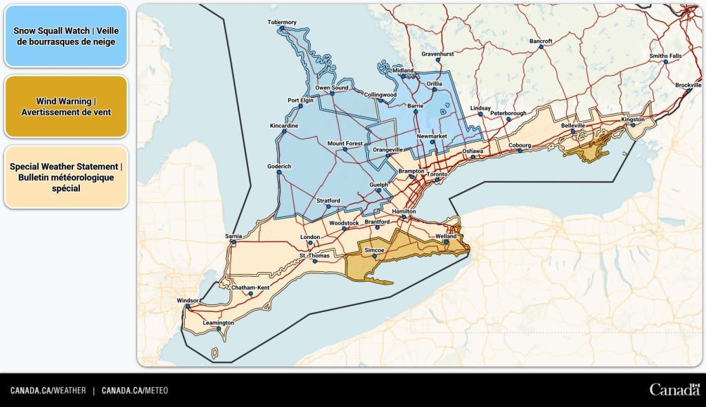
While northern parts of Ontario are preparing for a severe winter storm on Wednesday, Environment Canada has issued snow squall watches for regions east of Lake Huron.
Two distinct alerts have been announced, with areas further south likely to receive more snowfall compared to those in the north, although both warnings predict considerable amounts.
UPDATE: 60 cm of snow and strong winds this week in parts of Ontario
Places like Huron County, Port Elgin, and Mount Forest are forecasted to get between 30 to 50 cm of snow, with even higher totals possible locally.
The snowfall is expected to start Thursday morning and may continue into Saturday, bringing “near zero visibility at times.”

 X / @ECCCWeather ON
“Strong winds are also expected and a special weather statement is in effect. These strong winds will further reduce visibility in blowing snow,” the weather agency said.
“Travel may be hazardous and some routes may be impassable. Road closures are possible.”
Northern regions such as Owen Sound, Barrie, Orillia, and Northern York Region could see between 15 to 30 cm of snow, with some areas receiving even more.
“Snow squalls will shift throughout the day on Thursday before locking in place Thursday night,” Environment Canada said.
There too, strong winds will add to reduced visibility due to blowing snow.
Sig Weather Outlooks ⬇️
N: Heavy snow & blowing snow persists over NE & far NE ON, & lake effect snow is possible SE of Lake Nipigon Thurs
X / @ECCCWeather ON
“Strong winds are also expected and a special weather statement is in effect. These strong winds will further reduce visibility in blowing snow,” the weather agency said.
“Travel may be hazardous and some routes may be impassable. Road closures are possible.”
Northern regions such as Owen Sound, Barrie, Orillia, and Northern York Region could see between 15 to 30 cm of snow, with some areas receiving even more.
“Snow squalls will shift throughout the day on Thursday before locking in place Thursday night,” Environment Canada said.
There too, strong winds will add to reduced visibility due to blowing snow.
Sig Weather Outlooks ⬇️
N: Heavy snow & blowing snow persists over NE & far NE ON, & lake effect snow is possible SE of Lake Nipigon Thurs
S: Strong wind gusts persist across parts of S ON Thurs. Snow squalls develop off Lake Huron & Georgian Bay Thurs into Fri#ONStorm #ONWx pic. twitter. com/65SAAtuaz R – ECCC Weather Ontario (@ECCCWeather ON) November 25, 2025 INsauga’s Editorial Standards and Policies Last 30 Days: 32,818 Votes All Time: 1,256,584 Votes 1950 VOTES
Source link
X / @ECCCWeather ON
“Strong winds are also expected and a special weather statement is in effect. These strong winds will further reduce visibility in blowing snow,” the weather agency said.
“Travel may be hazardous and some routes may be impassable. Road closures are possible.”
Northern regions such as Owen Sound, Barrie, Orillia, and Northern York Region could see between 15 to 30 cm of snow, with some areas receiving even more.
“Snow squalls will shift throughout the day on Thursday before locking in place Thursday night,” Environment Canada said.
There too, strong winds will add to reduced visibility due to blowing snow.
Sig Weather Outlooks ⬇️
N: Heavy snow & blowing snow persists over NE & far NE ON, & lake effect snow is possible SE of Lake Nipigon ThursS: Strong wind gusts persist across parts of S ON Thurs. Snow squalls develop off Lake Huron & Georgian Bay Thurs into Fri#ONStorm #ONWx pic. twitter. com/65SAAtuaz R – ECCC Weather Ontario (@ECCCWeather ON) November 25, 2025 INsauga’s Editorial Standards and Policies Last 30 Days: 32,818 Votes All Time: 1,256,584 Votes 1950 VOTES
Source link


