





Currently, there are 145 active wildfires in northwestern Ontario, based on the most recent update from Ontario Forest Fires. This is one less than what was reported Tuesday night.
Among these fires, 49 are categorized as not under control, six are being held, eight are under control, and the rest are under observation.
Evacuation orders or alerts continue to be in place for areas near the following fires:
The largest wildfire in this region, called Thunder Bay 36, is still out of control and covers over 318,000 hectares.
“Fire Ranger crews, helicopters and heavy equipment operators are assigned to suppression efforts,” Ontario’s Aviation, Forest Fires and Emergency Services (AFFES) stated in their update on Tuesday evening.
“Recent rainfall over the past few days has helped lessen fire activity, allowing crews to make significant progress on the fire line.”
Wildfire smoke is visible in this photo taken between Thunder Bay, Ont., and Upsala July 13. (Sarah Law/CBC)
Forest fire danger ratings are mostly low or moderate throughout the northwest area; however, there are some spots with high risk in Sandy Lake, Red Lake and Fort Frances regions.
“Even though the northwest region has seen considerable precipitation recently, the fire risk is beginning to rise again,” said Ontario Forest Fires in a Facebook post on Wednesday.
“The possibility of holdover lightning fires continues to be a concern. The public is urged to exercise extreme caution and stay away from active fires while Fire Rangers and aerial suppression teams carry out their work.”
Ontario Forest Fires also mentioned that infrared scanning aircraft have been flying overnight into early morning hours checking for hotspots to help locate them quickly.
A Restricted Fire Zone remains active to help minimize human-caused fires.
New Wildfires Reported
Twelve new wildfires were confirmed in the region by Tuesday evening:
Fort Frances 45 (FOR045) is situated on an island at Bartley Lake. The 0.1-hectare fire is currently being monitored. Dryden 44 (DRY044) is about 17 kilometers west of Highway 599 and southeast of Press Lake. The 0.1-hectare fire is not under control. Dryden 45 (DRY045) is located at the northeast end of Rice Lake. The size of this fire is also 0.1 hectares and it’s not under control. Thunder Bay 61 (THU061) is positioned around 1.5 kilometers east of Wawang Lake and northwest of Little Harry Lake. This fire covers an area of 0.1 hectares and remains uncontrolled. Nipigon 76 (NIP076) can be found near Jobes Lake about 27 kilometers southeast of Fort Hope. This fire spans approximately 150 hectares and is not controlled. Nipigon 77 (NIP077) and Nipigon 78 (NIP078) are situated far north approximately16 kilometers north of Webequie; Nipigon 77 measures at70 hectares while Nipigon78 covers35 hectares – both remain uncontrolled. Nipigon79 (NIP079) is located far north around81 kilometers northeast of Webequie covering an areaof5hectares which remains uncontrolled. Nipigon80(NIP080)and Nipigon81(NIP081), which measure10hectaresand80hectaresrespectively; both sit roughly111kilometers eastof Webequieandarenotundercontrol. Nipigon82(NIP082)is locatedabout12kilometersnorthwestof Missisa Lakewithanareaof8hectareswhichremainsoutofcontrol. Sioux Lookout103(SLK103)is positionedonanislandon Wapesi Lakewithanareaof0.1hectaresthat isn’tcontrolled.
Highway Closures Currently Active
The province’s interactive highway map indicates that Highway527closure at Kiashke Zaaging Anishinaabek-Gull Bay First Nationhasbeenextendedtothe Highway811junction.
Highway811isalsoclosedduetoon-goingwildfireactivityexceptforlocaltrafficthat’s evacuatingthearea.
The First Nation now faces a mandatory evacuation order after lightning caused six wildfires nearby accordingtoareleaseissuedbythecommunityearly Tuesdaymorning.
Anupdate issued Mondaynightbythe Ontario Provincial Police(OPP)North West Regionstated:
“The OPP is currently assisting MNR with an evacuation order for Gull Bay First Nation which was previously self-evacuated by residents residing undermandatoryevacuationorderswhohavebeenaskedtoleaveimmediatelyandsoughtsafetyawayfromactivefires.” p >
Police have indicated that other communities will be monitored closely as residents should stay informedandbepreparedtoactquicklyiffurther evacuationordersoradvisoriesareissued. p >
“Additional information will be provided as it becomes available,” said OPP officials. p >
They strongly advised people for their safety as wellasthatsafetyforemergency responders: p >
- Keep away from affected areas; avoid going near wildfire scenes for photos or videos. li >
- Stay calm , follow all evacuation orders , emergency instructions issued by local authorities. li >
- Avoid non-essential travel within affected areas. li >
- Regularly check official sources for up-to-date information & evacuation news.
If you needtoevacuate , rememberto bring essential medications , ID , important documents , mobile devices & chargers plus items neededfor family members & pets.
No New Fires Found in Northeastern Region
No new wildfireswere recordedinnortheastern Ontarioon Tuesday. evening<p Asofthelatestreport Tuesdaynighttherewere40activewildfiresinthenortheastregion. Outoffouruncontrolled, fourcontrolled&therestbeingobserved.
Theforestfiredangerratingsremainlowthroughoutthenortheastwhileapocketmoderateriskexistsin North Bayarea.
Status Of Evacuations
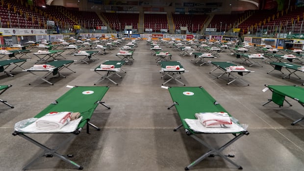
This year’swildfire seasonhasledmorethanadozencommunities&areas evacuateinrecentdaysincluding11First Nations.
Anestimated2415individualshave been evacuatedtosupportcommunitiesallaround Ontarioincluding Thunder Bay, Kennora, Ft Frances, Lac Seul, Sioook Lookout, Rd Lake, Barrie, Nigara Falls,&Torontoo.
A total312airpurifiers84airfilters&fiveairscrubbersweresenttomanycommunities impactedbymildfiresmokeaccordingto Ontariocorps
<p. Feeding Ontrios&EFDIFCshipdistributedfooditems To evacuees
<p. Global Medicdeliveredessentialsuppliesto Fort William Gardens Arena Intigerbay
City Facilities And Programs Back In Action
<p. As oftuesday, AQHIat Thunder Bayshowedlow-riskconditionsthroughoutthedayhowever, pollutionlevelsareexpectedtoriseagainwithmoderaterisktonightinto Wednesday
<p. The City resumednormaloperationsforallfacilities, outdoorprograms, Parks, pools,&recreationalamenitiesthat were temporarilyaffectedbywildfiresmoke.
Citycrews resumedregular outdoorworkwillcontinuetomonitconditions.Donationsforwildfire evacueesorganizedat Kiikenomaga Kikenjigewen Employment&Ttraining Serviceswarehousein Thunder Bay Ont. on Tuesdy.(Marc Doucette/CBC)
City officialsconfirmedthey’repreparedtosupportregionalresponseteam&additional evacuationsifnecessarycontinuingclosecollaboration withemergencymanagement partners acrossregions.
Chiefs Of Ontariolaunchedawildfireupdates&supportpagehelpingshareinformationidentifyurgentneedsadvocatingcoordinatedemergencysupportforprovincial First Nations.
Source link