


Mississauga is set to experience heavy rain as a weather system moves through the area.
This week, Mississauga has seen 60.6mm of rainfall. A Special Weather Statement has been issued for the city, with a cold front arriving that will bring an additional 10-20 mm of rain and a chance of thunderstorms on Saturday.
Water levels in local waterways, including creeks, rivers, ponds, and lakes are currently high, raising the risk of further flooding. Recent rains have saturated the ground, making it less able to absorb more moisture. Consequently, heavy rain could lead to flooding, swift currents, and slippery banks and shorelines. For safety reasons, residents are advised to stay away from rivers, creeks, stormwater ponds, and Lake Ontario.
Short bursts of intense rainfall can also overwhelm storm drains quickly, causing water to pool on roads and in low-lying areas.
Previously this week, some spots within the Credit River watershed recorded water levels above bank-full with minor flooding reported in several parks throughout Mississauga. About 20 millimeters of rainfall was recorded in parts of the city; similar conditions are expected until Thursday.
media@mississauga. ca
905-615-3200 ext.5232
TTY: 905-896-5151
Get email updates
Source link
Important Reminders
Residents should clear storm drains near their driveways and backyards of leaves and debris to minimize flooding risks. It’s also wise to prepare ahead of time and exercise caution while traveling. Drivers should remember to slow down on roadways, keep a safe distance from other vehicles, allow extra time for travel and drive based on weather conditions. Avoid driving through flooded roadways; if there’s standing water on a road that makes lanes impassable, steer clear by turning back or finding an alternate route. Avoid areas prone to flooding. Watch out for washouts around rivers, creeks and culverts.City’s Response
The City is keeping an eye on local waterways and low-lying regions in collaboration with conservation authorities under the Credit Valley Conservation (CVC) Flood Watch program. City crews are actively monitoring storm drains (catch basins) along city roads for signs of water ponding or flooding issues. You can report any problems with storm drains online or by calling 311 (905-615-4311 for those outside City limits).Understanding Flood Watches or Warnings
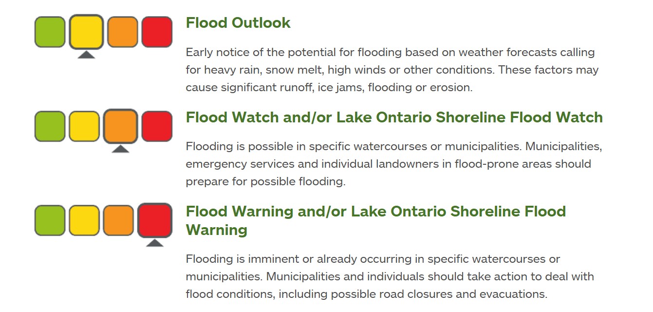
Flood watch: Flooding could occur in certain areas. Flood warning: Flooding is currently happening or may happen soon. Conservation Authorities like CVC issue these alerts when conditions such as heavy rain or melting snow could result in rising water levels. If a flood warning is issued, take immediate action to protect yourself from danger and your property from potential flood damage.
Increased Flood Risk During Spring
Spring often brings together rapid snowmelt along with heavy rains which can create ice breaks leading to higher flood risks. These factors can cause water levels to rise faster than what drainage systems can handle. If you have questions about flooding concerns please reach out via 311. Please keep checking the City of Mississauga Newsroom for updates. Follow @citymississauga, @saugaparksrec, @CVC_CA and @TRCA_HQ on X for real-time information. You can check weather updates using the Weather Network website as well as tools provided by Credit Valley Conservation or the Weather CAN app from Environment Canada for current weather conditions details.Stay Ready
Paying attention to changing weather patterns while preparing your family and home can significantly help during this season. A little effort now can safeguard your loved ones as well as your property when temperatures start rising again. You can learn more about flooding situations in Mississauga here.Tags
Media Contact Information
City of Mississauga Media Relationsmedia@mississauga. ca
905-615-3200 ext.5232
TTY: 905-896-5151
Get email updates
Source link


