




The tornado watch has been lifted for London and Middlesex County after a hectic afternoon of severe weather in southwestern Ontario.
A severe thunderstorm watch and yellow heat warning are still in effect for the London area as of 8 p. m. A yellow severe thunderstorm warning is also active for St. Thomas, Elgin County, and regions between London and Chatham-Kent.
Thousands were left without power in Huron, Lambton, Oxford, and Perth counties after a major storm hit the region around 5 p. m., having crossed Lake Huron from Michigan.
Nearly 5,000 residents lost power in Grand Bend and Lambton Shores, while almost 3,500 were without electricity near Goderich, affecting Ashfield-Colborne-Wawanosh, Central Huron, and North Huron.
Several roads have been affected by fallen trees and downed power lines throughout the area, according to Ontario Provincial Police. This includes Highway 8 from Clinton to Road 140, Highway 23 near Road 165, and Perth Line 55 from Highway 23 to Road 166.
West Region OPP warns that multiple roads are closed due to downed trees and hydro lines caused by severe weather conditions.
Additional communities especially in Huron and Perth counties are also facing road closures due to the storm.
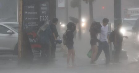
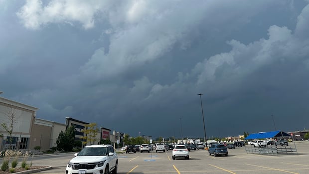
Some of… pic. twitter. com/Qao Me0LF81 -OPP_WR Power was expected to be restored in most areas by around 7:30 or 7:45 p. m., but outages persisted as of 8 p. m., according to Hydro One’s outage map. Roughly 2,000 individuals were impacted near Woodstock as well. In London, a small branch fell on a power line along Empress Avenue cutting off electricity to residents in Blackfriars and West London. London Hydro estimated power would be back on by about 10:30 p. m. This storm system triggered a red thunderstorm warning for regions north of London extending into Midwestern Ontario along the Lake Huron shoreline from Ipperwash to Goderich. A red tornado warning had also been issued for Clinton area including Mitchell, Seaforth, and Vanastra but was rescinded as the storm advanced eastward at speeds between 75 km/h to 100 km/h according to Environment Canada. It’s not clear if there was an actual downburst or tornado since no significant damage has been reported so far. Environment Canada first issued an orange-level tornado watch at 4:25 p. m. ET stating that conditions were favorable for thunderstorms capable of producing tornados with strong winds, large hailstones, and heavy rainfall. Severe weather meteorologist Rob Kuhn indicated that the highest risk was anticipated between 4 p. m. and 8 p. m. ET with chances of heavy rainfalls, large hailstones along with damaging wind gusts. “These thunderstorms could pack quite a punch,” said Kuhn early in the day. “There is also a risk of an isolated tornado system through late this afternoon to early this evening so it’s got potential for being very active.” A storm system moves into the London region late Wednesday afternoon. This photo was taken from Pall Mall Street in downtown London looking west (Andrew Lupton/CBC). A quick-moving thunderstorm swept through London around 2 p. m., bringing heavy rain alongside hail in some locations. “The black cloud came over, and all of a sudden golf ball-sized hail stones were coming down,” said Matt Goldsmith who was working on a home in east London at that moment. The hail caused dents on Goldsmith’s truck but stopped soon enough; he mentioned that the sun returned just as he finished his lunch. However more rain was on its way later on.
Source link
Additional communities especially in Huron and Perth counties are also facing road closures due to the storm.
Some of… pic. twitter. com/Qao Me0LF81 -OPP_WR Power was expected to be restored in most areas by around 7:30 or 7:45 p. m., but outages persisted as of 8 p. m., according to Hydro One’s outage map. Roughly 2,000 individuals were impacted near Woodstock as well. In London, a small branch fell on a power line along Empress Avenue cutting off electricity to residents in Blackfriars and West London. London Hydro estimated power would be back on by about 10:30 p. m. This storm system triggered a red thunderstorm warning for regions north of London extending into Midwestern Ontario along the Lake Huron shoreline from Ipperwash to Goderich. A red tornado warning had also been issued for Clinton area including Mitchell, Seaforth, and Vanastra but was rescinded as the storm advanced eastward at speeds between 75 km/h to 100 km/h according to Environment Canada. It’s not clear if there was an actual downburst or tornado since no significant damage has been reported so far. Environment Canada first issued an orange-level tornado watch at 4:25 p. m. ET stating that conditions were favorable for thunderstorms capable of producing tornados with strong winds, large hailstones, and heavy rainfall. Severe weather meteorologist Rob Kuhn indicated that the highest risk was anticipated between 4 p. m. and 8 p. m. ET with chances of heavy rainfalls, large hailstones along with damaging wind gusts. “These thunderstorms could pack quite a punch,” said Kuhn early in the day. “There is also a risk of an isolated tornado system through late this afternoon to early this evening so it’s got potential for being very active.” A storm system moves into the London region late Wednesday afternoon. This photo was taken from Pall Mall Street in downtown London looking west (Andrew Lupton/CBC). A quick-moving thunderstorm swept through London around 2 p. m., bringing heavy rain alongside hail in some locations. “The black cloud came over, and all of a sudden golf ball-sized hail stones were coming down,” said Matt Goldsmith who was working on a home in east London at that moment. The hail caused dents on Goldsmith’s truck but stopped soon enough; he mentioned that the sun returned just as he finished his lunch. However more rain was on its way later on.
If You Get A Tornado Warning
Environment Canada advises everyone continue watching weather alerts and forecasts closely. If there’s ever a tornado warning issued for your area officials say you should go inside immediately moving towards a room located on the lowest floor away from outside walls or windows; places like basements bathrooms stairwells or interior closets can provide safe shelter. If you’re staying in mobile homes vehicles tents trailers or other temporary structures you should relocate into sturdy buildings when possible instead! The agency urges people take cover right away if they hear roaring sounds see funnel clouds swirling debris near ground level or notice threatening weather moving their way!The Storms Amid Heat Warnings
This recent tornado watch coincides with ongoing extreme heat warnings affecting London’s area too! On Wednesday temperatures during daytime reached approximately 32 C while humidex values made it feel closer to 41 degrees! The Middlesex-London Health Unit reminded folks about taking precautions regarding heat such as drinking lots of water limiting outdoor exposure seeking shade avoiding strenuous physical activities! This unit also warned against leaving children/pets unattended inside parked cars! A complete list featuring recommendations aimed at preventing heat-related illnesses plus additional resources can be found over at Middlesex-London Health Unit’s website! No relief expected overnight though with temperatures projected only dropping down towards 19 C! Environment Canada noted there’s still some chance concerning thunderstorms continuing into late hours come Wednesday night.. Mainly cloudy skies predicted Thursday accompanied by roughly 40 percent chances seeing showers arriving late afternoon potentially risking another round involving thunderstorms alongside high reaching up toward 27 C however feeling closer toward 35! An overcast Friday awaits us too containing only about thirty percent probability involving showers hitting while highs hover nearby twenty-six degrees Celsius whereas Saturday keeps this pattern going finishing off weakly showing highs staying around twenty-four degrees Celsius overall..Source link