




After a summer filled with thunderstorms, flooding, and record rainfall in parts of eastern Ontario, forecasters indicate that residents in the Kingston area can look forward to a more gradual transition into winter this year, with fall-like weather sticking around well into November.
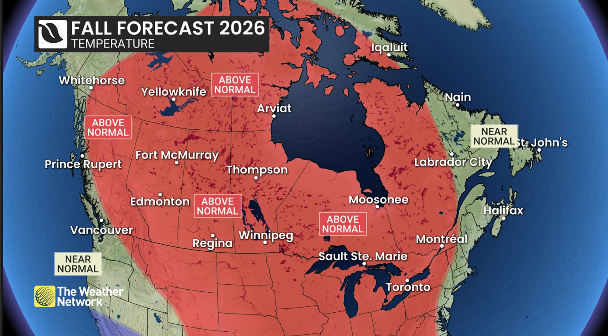
The Weather Network’s 2026 Fall Forecast suggests that a notably strong El Niño will influence weather patterns across Canada for the rest of the season, raising the chances of above-normal temperatures and postponing persistent winter conditions.
For Kingston and much of eastern Ontario, this means what meteorologists refer to as an “open or extended fall.”
“The theme is really an extended fall,” senior meteorologist Doug Gillham said during an interview Thursday. “We don’t expect winter to settle in early. In fact, we think it will be delayed.”
The fall outlook follows a summer that many residents remember differently than the statistics suggest
Doug Gillham Senior Meteorologist, The Weather Network
This forecast sharply contrasts with last year.
“We were warm more consistently through September and October, and then the bottom fell out on Nov. 10, and winter set in early,” Gillham said. “This year is much different.”
Rather than a sudden shift in seasons, forecasters anticipate the typical fluctuations that usually characterize autumn.
“The second half of September and October will see more of that normal up-and-down pattern,” Gillham said. “It’s different from last year because warmth won’t dominate the whole season. We’ll still have cooler periods but we don’t expect winter to take hold early.”
Gillham warned that predictions for a mild fall don’t mean every day will be warm.
“People hear ‘mild fall’ and think every day is going to be warm. It doesn’t mean that,” he explained. “It just indicates that in the usual temperature ups-and-downs, milder days are likely to prevail.”
For those living in Kingston, occasional chilly spells, frosty mornings, and even an early snowfall aren’t off the table.
“You could still get snow in mid-fall,” Gillham noted. “But it would likely be brief rather than marking the start of winter.”
A key factor behind this forecast is an exceptionally strong El Niño occurring in the Pacific Ocean. The network states this El Niño could become one of the most powerful ever documented.
Gillham mentioned that strong El Niño events typically promote milder Pacific air across Canada while limiting how far south Arctic air masses can reach.
“You have a stronger jet stream which restricts Arctic air from plunging south and lingering,” he explained. “We believe Canada will predominantly experience milder Pacific air instead of Arctic air.”
The Weather Network senior meteorologist Doug Gillham expects a more gradual transition into winter for Kingston and area. (Photo supplied/Pelmorex) Pelmorex / Photo supplied
This fall outlook comes after a summer many locals recall differently than what statistics show.
Gillham pointed out that how people perceive weather often depends on personal experiences rather than averages over time.
Meteorologists call this “recency bias,” where recent weather events influence public perception long after they occur.
“We kind of joke internally that every spring is the worst spring ever,” Gillham said. “Nobody remembers the previous spring.”
A similar effect happens during summer when rainy weekends or soggy outdoor weddings leave stronger memories than typical weather weeks.
“That day you were on the golf course? That’s what sticks with you,” he stated.
Despite some people thinking summer was moderate overall, it actually ended warmer than usual across much of eastern Ontario.
Gillham mentioned there weren’t prolonged heat waves but temperatures stayed consistently above average.
“We had fewer 30-degree days than normal,” he said. “There weren’t any long stretches of extreme heat; however we had plenty of days just slightly warmer than average along with significant heat at times during early July.” p >
Kingston’s rainfall story also looked quite different compared to neighboring areas.
While Kingston wrapped up wetter than usual overall this season,
it missed out on extreme rainfall totals seen further east.
“When I compare July stats from Ottawa versus Kingston, it really shows how localized precipitation can be,”Gillham remarked.” p >
The contrast was striking as Ottawa recorded its wettest summer ever while Kingston had relatively moderate conditions despite being only hours apart.” em> - >P >
These differences highlight challenges meteorologists face when forecasting summers.
“Summer precipitation tends to vary greatly by location,”Gillham shared.”Everyone wants to know if their backyard will stay dry while they’re grilling outside.” P>
The increased moisture was welcome relief for many farmers who faced severe drought conditions throughout eastern Ontario last year.
The agriculture sector has been navigating wildly different weather extremes over two years.
“In 2025, many parts saw one of their driest growing seasons recently,”reports detailed significant deficits, broad crop stress, and concerns about dwindling water supplies due to less than 40% normal July rainfalls.”Gillham continued
This year’s challenges came from another angle.
“According to reports, spring chilliness paired with dampness delayed planting schedules throughout eastern Ontario,”he explained. A few producers even replanted portions due to wheat losses caused by winterkill. Later heavy rains made fieldwork tougher during harvest time too.
“It was relief since we didn’t face drought again.” Eastern Ontario farmers contended with disease pressures alongside localized flooding issues here especially near Ottawa. Nevertheless, many places like Kingston benefited from improved soil moisture leading reduced irrigation needs. “P”You’re not watering nearly as often anymore,”Gillhamsaid”You didn’t have run AC constantly either.” Spring moisture paired with high summer temperatures also contributed significantlytoatickpopulationincreaseconfirmedreportsrevealed38%growthmostlyin Ontario. Publichealthofficialscalleditsummerofticksaswarm, snowlesswinterhelpedticks thrivewhilewet springs ledto higherdeermousepopulationshostinginfectiousnymphs. Earlyandconsistentheatspeduptickdevelopmentextendingfeedingreproductionperiodsand intensifiedhigh-riskzonesacross Eastern Ontario. Lookingforwardforecastersseeweatherconditionsbecomingbetterforoutdooractivitiesasfallprogresses.”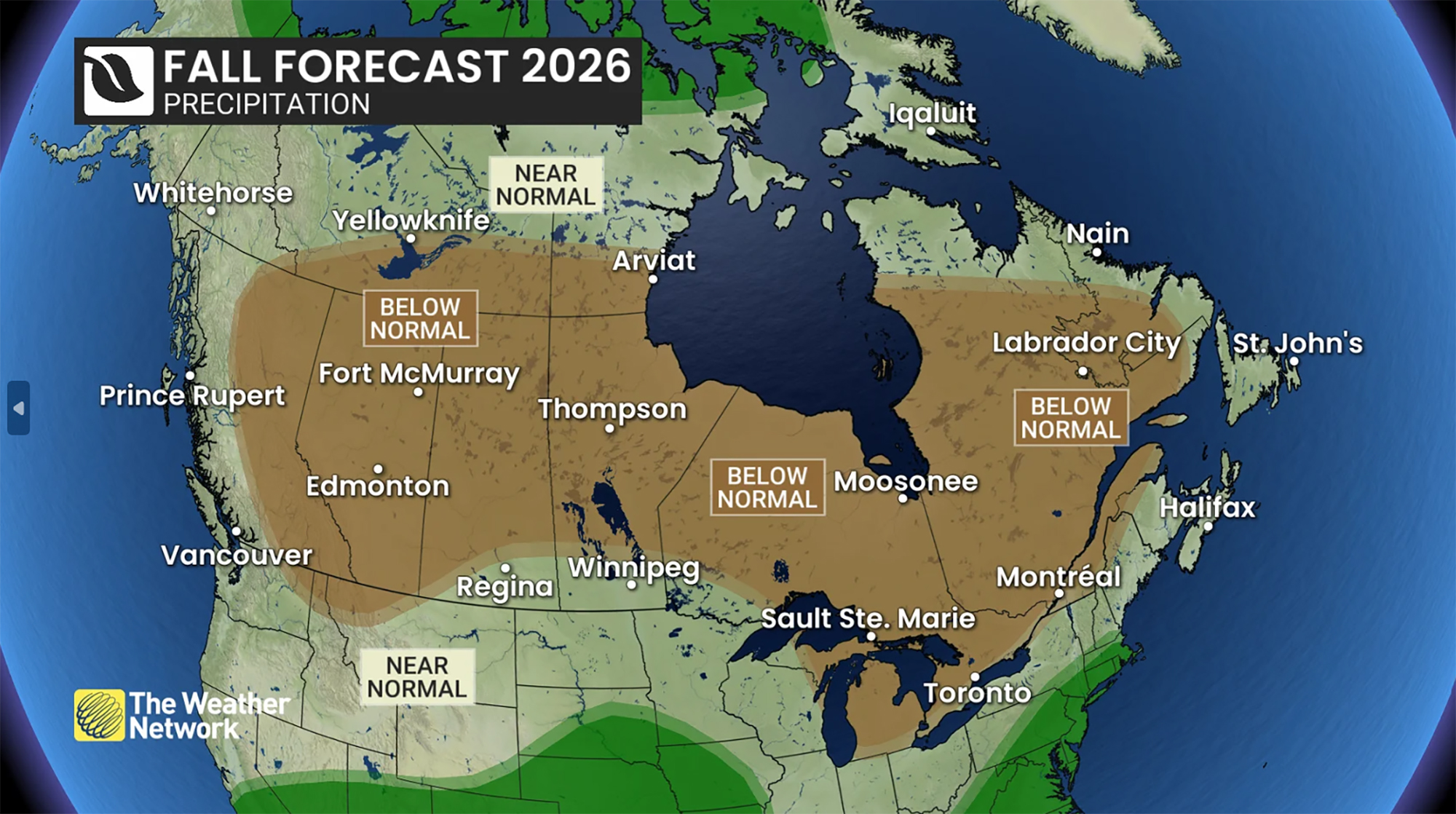 This map shows precipitation trends expectedthisfallacross Canada accordingto The Weather Network(Photo Supplied/Pelmorex)
Althougheastern Ontariostillfacesmajorautumnstormrisk, the Weather Networkanticipatesfewerclassicfallstormsbeingexperiencedin Octoberand November. ” ! > ; “< strong>”</strong>”< p>" People should stay alert since we’re not entirely safe from storms," Gillsaid." However, weexpecttherewillbe fewer storms overall during these months." </ b > ; For those hopingtotoenjoythearea’sbeautifulfoliage, hiking trails, and waterfront parks before snow arrives, this could bring some good news. “We expect oncewegetpastthenext10days we’ll moveintoapatternthatallowsusoutsideamoreoftenandenjoythefabulousfall colors’ ‘said Gilhanm.'” At present, theforecastindicates Kingstonwillexperienceautumnasit’smeanttobe: aseasonnotedfornormalvariationsratherthanextremes.’ Temperaturesarelikelytoriseandfallasdifferentweatherpatternsbattleforcontrolbutunlikelastyearforecastersdonotbelievewinterwillstrikewithanearlyblow.’ “‘Novemberisexpectedto bestillchillywithstandardtemperature dropsoffbythen,’Gillsaid.’Butwefeelnovemberwillfeelmorelikefallthanwinter.’” “Forareaswhichhaveexperiencedconsecutiveyearsfilled withdrought, floods, anduncertainty, Gillhamsaysalongercalmer autumnmightjustbethekindofforecast Kingstonneeds.”
Source link